Chapada Diamantina
Chapada Diamantina
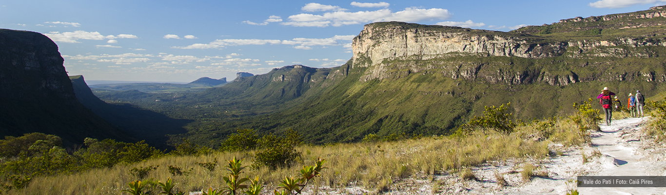
The Chapada Diamantina National Park covers an area of 152,575 hectares(ha) and is located in Serra do Sincorá, which is part of the Cadeia do Espinhaço. It is located in the center of the state of Bahia and covers 5 municipalities: Lençóis, Palmeiras, Andaraí, Mucugê and Ibicoara and its headquarters are in the city of Palmeiras. The region considered Chapada Diamantina goes far beyond the National Park, encompassing other municipalities and various attractions for visitation. The majority of 1 day tours take place outside the national park, on private properties, subject to the charge of a visitation fee. already the trekkings are inside the national park, with long walks through wonderful places.
Traveler's Responsibility
The traveler has a moral responsibility to evaluate the behavior of his guide in relation to all the precautions that involve conducting visitors, such as care for the environment, for travelers and for everything that involves hygiene in a natural environment. If he sees any inappropriate behavior by the guide, he must call the attention of the guide and file a complaint with the competent authorities.
Chapada Diamantina: As Cidades e Vilas
Lençóis
The city of Lençóis, in the northern region of the Chapada Diamantina National Park, it is the one that receives the most tourists since it has the best infrastructure to serve them and is 420 km from Salvador. Its historic mansions were transformed into inns, restaurants, agencies and other services. Some tours and treks have Lençóis as a base, such as Marimbus, Fumaça por baixo, Mixila, Cachoeira dos Mosquitos, Serra das Paridas, Rio Mucugezinho + Poço do Diabo, Morro do Pai Inácio, Grutas da Fumaça, Pratinha, Torrinha e Lapa Doce.
Palmeiras e Vale do Capão
Also to the north of the Chapada Diamantina National Park, in the municipality of Palmeiras, we have the village of Capão Valley. Both Palmeiras and Vale do Capão have a structure of inns, restaurants, tourist agencies, markets, bakeries, etc. The road to Palmeiras is paved. From the city to the village of Vale do Capão the road is dirt, often very bumpy due to the rains, so the short distance can take a longer journey due to the slowness of travel. The Vale do Capão is one of the entrances to the famous trail Vale do Paty. It is also the closest village to the famous Cachoeira da Fumaça and the beautiful trail of Clear Waters. In this municipality there are attractions such as Morro do Pai Inácio, Morro do Camelo, Campos of Saint John and others.
Na região central do Parque Nacional da Chapada Diamantina há as cidades de Andaraí, at an altitude of 450 meters and Mucugê, at 1,000 meters of altitude. They are very close (40 km by road), but with the large difference in level, the climate between them is very different.
Andaraí
Andaraí is one of the gateways to paradise in Paty Valley, the most famous trek on the chapada, in addition to having the beautiful Waterfall of Ramalho. The city does not have much tourist structure, lacking sophisticated restaurants, for example.
Mucugê
Mucugê is the municipality with the largest area within the Chapada Diamantina National Park, with some attractions such as Bizantino Cemetery, the Always Live Project (which has Museu Vivo do Garimpo, Piabinha Waterfall and Cachoeira do Tiburtino), the waterfalls of Cardoso, Funis, Swallows, Three Bars and Crystals. The city has good inns and restaurants to welcome travelers.
Igatú
Between these two cities (Andaraí and Mucugê) there is the village of Igatú, famous for its ruins and for being bucolic, nestled in the mountains, with only approximately 500 inhabitants. Charming inns and good restaurants make it the ideal place for those who want little movement and a peaceful life. In this village it is possible to visit an old gold mine of diamonds, as well as ruins of dwellings from the times of settlement and diamond extraction. There is also Rampa do Caim, a beautiful viewpoint where it is possible to observe the meeting of the Pati and Paraguassú Rivers and all their unique beauty.
Guiné
On the east face of Serra do Sincorá there is the village of Guiné, belonging to the Municipality of Mucugê, which is another gateway to Paty Valley. The Serra do Esbarrancado shapes a perfect view with its beautiful cliffs for those who are going to start walk to Pati Valley. There are few inns and all very simple, as well as restaurants.
Ibicoara
At the southern end of the Chapada Diamantina National Park is the city of Ibicoara. Of all the above, it is the only one that does not have historic buildings, with an urban center that does not call attention. But from the city, the view is already a spectacle, with the Serra do Sincorá growing from the ground to the clouds, forming a beautiful wall. Besides the waterfalls of Buracão, Fumacinha, Licuri, Véu de Noiva and Rio Preto, one of the best attractions in the city is the countryside and the way people live there. The contact with the countryside is intense and the accommodation options are simple and cozy, all nestled in deep valleys in the south of Serra do Sincorá.
The Chapada Diamantina region is much larger than the Serra do Sincorá, which only houses the Chapada Diamantina national park. To the west of the national park there is another extension of the Espinhaço Chain, which even has the highest peaks in the northeast of Brazil. This range ends in the valley of the São Francisco River. The cities of Rio de Contas, Abaíra, Piatã and Livramento de Nossa Senhora are located in this region.
The map below divides the state of Bahia in regions. Note that the Chapada Diamantina region is in the center of the map and the Chapada Diamantina National Park is highlighted.
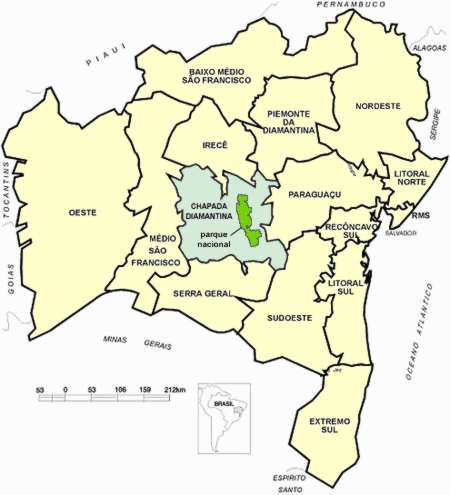
Fonte: http://www.bahia.ws/mapa-bahia/chapada-diamantina
Climate and Relief
The climate of Chapada Diamantina is semi-humid tropical, although in some regions semi-arid predominates. The altitude varies, as the park is a mountain region. Therefore, to enter Chapada Diamantina National Park it is necessary to go up the mountain range, since the cities are below the mountains. The average altitude within the PNCD is 1,000 meters, but the lowest places are at 440 meters and the highest at approximately 1,600 meters. Outside the Parque Nacional da Chapada Diamantina (to the west) is the highest peak in northeastern Brazil, the Pico do Barbado, with 2030 meters of altitude.
The satellite image below shows the northern half of the Chapada Diamantina National Park, between the cities of Lençóis and Palmeiras (far north) and Mucugê (center). This region is where most treks are concentrated, such as Fumaça, Mixila and Vale do Paty.
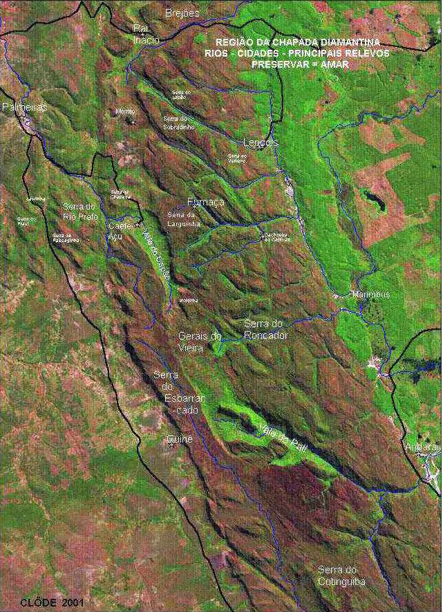
Fonte: http://www.oocities.org/br/isrcl/satelite.jpg
Vegetation and Geology
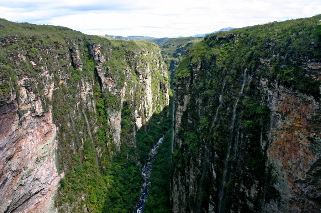
The Chapada Diamantina National Park is located in a region of transition between biomes, which is why it covers areas of cerrado, caatinga, rocky fields and highland forests. And the most impressive thing is to get to know up close the mix of these biomes that form one of the most exuberant landscapes in Brazil. There are endemic plant species that mix with others and form a beautiful scenario that only those who visit the region know. Bromeliads, Orchids, Semper Vivas and Cinnamons of Ema are abundant plants and easily found on the tours.
Within the park, the most frequent rocks are conglomerates, claystones, siltstones, sandstones and quartzites, dominating the mountain region. Around the park there are limestone rocks, glacial rocks and primitive gneiss sediments. With less incidence there are also recent sediments and volcanic rocks.
The mountainous landscapes of the National Park of Chapada Diamantina and its surroundings were formed by the phenomenon called uplift, which occurs when pressures coming from from within the earth's crust end up raising part of the surface. Finally, time is another responsible for beautiful landscapes, as it causes erosion, changing them through rain and wind.
Apas and Municipal Parks
With 125,400 hectares, APA Iraquara-Marimbus encompasses 5 municipalities: Lençois, Andaraí, Palmeiras, Iraquara and Seabra. It was created in 1993, with the aim of ensuring the conservation of natural areas threatened by undue human occupation and thus providing tourists with the opportunity to discover the beauty of the region.
The northern part, in Iraquara and Seabra is the region of limestone caves. Palmeiras is the region of the most famous hills, such as Morro do Pai Inácio and Morro do Camelo,where the flow of tourists is intense and there are daily itineraries. In the region of Lençóis and Andaraí is the area called Marimbus, also known as mini-pantanal.
In Marimbus, the rivers Santo Antônio, São José and Utinga receive water from the mountains of the north of the parque nacional, among them the Mucugezinho, Preto, Capivara, Roncador, Caldeirão and Garapa rivers and form the landscape that attracts many tourists on daily routes. The silting up caused by the sands that descended the mountain because of the mining caused a great environmental impact, forming beaches and extensive sands.
Muritiba Natural Municipal Park
In the city of Lençóis we have the Natural Municipal Park of Muritiba, which is a great tour to discover the history of Lençóis and learn about the Geology of the region. It is necessary to pay a visitation fee and in a certain area it is mandatory to hire a driver/environmental monitor.
Parque Municipal de Mucugê
The Parque Municipal de Mucugê, with 570 hectares, houses the Living Museum of Garimpo, consolidating the cultural identity of the municipality, which was the first city of Chapada Diamantina, Where diamonds were discovered in 1844, starting the diamond cycle in Bahia. Already in Projeto Sempre Viva, also inside the municipal park, it is possible to visit the Tiburtino and Piabinhas waterfalls.
Forest Fires
One of the main enemies of the park and of nature in general is fire (IF). We know that it can occur naturally, but for that it is necessary to gather some factors, which rarely happens. Therefore, in recent years the fires that have occurred in the park have been caused by man. Many fires are deliberate and therefore a crime, and those responsible must be punished. The body responsible for monitoring, preventing and combating forest fires within the PNCD is the Chico Mendes Institute of Biodiversity (ICM-BIO). In areas adjacent to the PNCD, the body responsible for inspection, investigation and punishment is INEMA, through complaints from the Public Ministry of Bahia.
The national park is not regularized, there are still land issues to be resolved, and this prevents ICM-BIO from closing the doors of the national park to control the entry and exit of people. The land issue also prevents the creation of a law that obliges travelers to hire an accredited guide to make the trails inside the park.
If this were possible, the guide would be legally responsible for the group that is leading for any environmental damage or for any possible medical care, needing to know the trails, support points and first aid procedures well. Others, though few, are accidental and perfectly preventable. Cigarettes must be put out carefully and glass or aluminum remains must not be left behind.
To cook, the guide must use stoves, as making a fire inside the PNCD is a crime!
Chapada Diamantina- History Summary
According to FUNCH (2002), the history of occupation by colonizers and enslaved people in the region of Chapada Diamantina began with the exploitation of gold and diamonds . At the beginning of the 18th century, gold was discovered in the town of Jacobina, in the north of Chapada Diamantina. Initially, in the Jacobina region, gold exploration was clandestine, but from 1720 it was finally released by the Empire. After four years, exploration was allowed in the southwest region of Chapada Diamantina, where the city of Rio de Contas is located today. The exploitation of gold in Bahia continued for two more centuries, since in the 20th century they began to run out.
Diamond exploration started around 1730, but it was done illegally and clandestinely until 1832, when it was released. In the meantime, deposits were discovered and the diamond character of the region was recognized. In 1844, a merchant who traveled through the villages of the region recognized the gravel he always saw in the chapada Velha when he walked in the region of Mucugê.
After a few attempts, they found diamonds in the stream that cuts through the city, and then began to explore the region. It didn't take long for the news to spread and many prospectors began to arrive, populating and leveraging the cities in the region.
Consequences
From Mucugê to Morro do Chapéu (to the north), settlement intensified and new villages emerged, such as Igatú, Andaraí and Lençóis. strong>
This region, which encompasses the gold and diamond cycles, became known as Chapada Diamantina. This race of people after the “easy wealth” that the exploitation of these materials provided, also resulted in political struggles. People from the Central Plateau, the São Francisco Valley, Minas Gerais and the Sertão Baiano came across people from the Recôncavo Baiano and even the Portuguese who represented the crown.
This generated many conflicts and, along with the decline of the mining, there was a power dispute in which Coronel Horacio de Mattos stands out, an influential and combative colonel from Chapada Velha, today Brotas de Macaúbas. Through some conflicts and some alliances he gained a lot of influence and when the Prestes Column passed through the region he was assigned by the Federal Government to pursue his troops. And so he made it to Bolivia.
All this power dispute had consequences, which added to the drop in mining activity, left the Chapada Diamantina region economically annihilated. With the victory of the Republic in the Revolution of 1930, Col. Horácio de Mattos responded to the pacification appeals and surrendered his weapons. Once disarmed, Horácio de Mattos and other colonels are arrested and sent to Salvador.
Under protests against his arrest, he was released on May 13, 1931 and was murdered two days later at the behest of relatives of a victim he had made in the past. With the economy annihilated and without political leadership, the region of Chapada Diamantina declines and its population begins to migrate to coffee plantations and mining in other states of Brazil.
Prohibition of Diamond Mining
With the ban on mining, the inhabitants of Chapada Diamantina had to look for other alternatives to sustain themselves. Therefore, the tourist activity appeared, and with it came the conflicts of a philosophy of environmental preservation with the traditional mining activity, which was responsible for enormous environmental degradation.
Until then, the idea of preserving the environment did not exist, and the change that occurred next brought new people, and with them new ideas on how to carry out activities in natural environments while minimizing the environmental impact. From the 1990s onwards, tourists interested in the beauties of the mountains, waterfalls and other natural beauties began to arrive at Chapada Diamantina. Thus, the region of Chapada Diamantina was able to emerge from the economic decline it was in.
It is still possible to find prospectors in the park's mountains, but they carry out the prospecting manually, without the help of dredgers (engines) that previously helped in the excavations and this makes their work more tiring and less efficient. Therefore, those who still risk finding diamonds today have not adapted to tourism as a means of livelihood. But they are few and often elderly.
It is important to remember that they are responsible for the trails that Extreme EcoAdventure walks, since they are old trails used for the disposal of mining. The agency's team, including the owner of Pousada Luar do Sertão (Marcelo Cardoso), was responsible for exclusive expeditions on old paths used by prospectors that had been “abandoned” since the official closure of the mine (1996). Such expeditions had the objective of reopening these ancient trails that cross the mountains and pass by wonderful waterfalls. The result of this expedition was the Garimpo Trail,https://www.extremeecoadventure.com.br/trekking/chapada-diamantina-trilha-do-garimpo-3-4-ou-5-dias-exclusivo 4 or 5 day trekking.
Chapada Diamantina - Fauna
Hunting is, like fire, one of the worst enemies of animals in the region. Even today there is hunting taking place in the areas of the park and the lack of inspection threatens the fauna. Today reports of groups seeing large animals are not frequent. The most frequent animals are: snakes, lizards, grasshoppers, crickets, mocós (rodent), hedgehogs, marmosets, bats, armadillos and a wide variety of birds.
Referência Bibliográfica:
FUNCH, ROY. Livro Um Guia Para a Chapada Diamantina. Gráfica e Editora Nova Civilização Ltda, 2002